Published December 2024.
Summary
The IRIS model estimates that climate change uplifted the intensity of a tropical cyclone like “Chido" from a Category 3 to Category 4. A “Chido” type storm is about +40% more likely in the 2024 climate compared to a pre-industrial baseline. In a future +2.6°C warmer world we estimate TC Chido will be a further +26% more likely compared to now.
Background
Tropical Cyclone Chido had a life-time minimum pressure of 929 hPa over the Southern Indian Ocean making it a Category 4 tropical cyclone. It was the second tropical cyclone of the 2024/25 South Indian Ocean season. Chido was a Category 4 as it crossed the Island of Mayotte causing many fatalities.
The IRIS model (Sparks and Toumi, 2024) can be used to infer the additional strengthening of a “Chido” type storm that can be attributed to recent warming or more specifically to recent changes in potential intensity (PI). We first need to consider the change in the thermodynamic environment. There has been a recent global warming of about 0.2°C/decade putting the 2024 global mean temperature close to about 1.3°C above pre-industrial temperature. ERA5 reanalysis is used to calculate monthly mean PI fields between 1980 and 2024. We consider global warming to manifest itself differently with latitude. We have low confidence in attributing regional or longitude trends to global or anthropogenic warming. The regional changes are more likely to be caused by decadal variations and less likely to be sustained or representative of global warming.
To calculate the PI field in any given year we apply the corresponding monthly (August) global zonal mean trend to the 1980-2024 monthly mean PI field. In this way we can estimate the regressed anomalous PI field in any month since industrialisation and scale this by the simultaneous global mean surface temperature. This regressed value is not the actual PI now but that portion due to a linear change since 1980. The pre-industrial state is equivalent to the global mean surface temperature of the 1950s. The pre-industrial value of PI is determined by regressing ERA5 backwards in time.
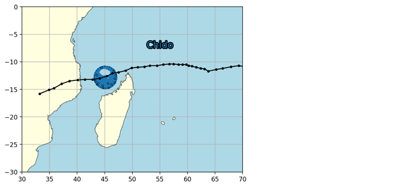
The frequency of landfall is the next consideration. The IRIS model does not change the number of events in the South Indian Ocean, only the initial life-time maximum intensity is modified by the PI. Figure 1 shows the events of the 10,000 year simulation of TCs near Mayotte (within 2° degrees of the actual landfall location). The tracks in IRIS are generated as deviations of the observed/historical “parent tracks”. This method does convert many historic “near misses” to then enter the region of interest.

Maximum wind speed at landfall
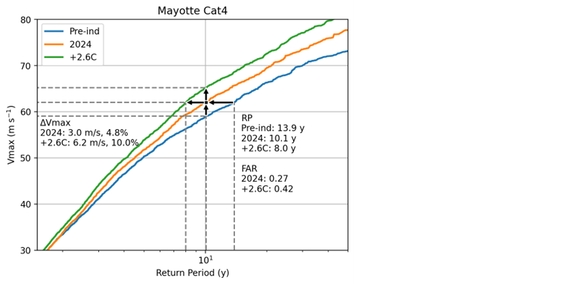
Figure 3. Shows the return period plot for wind speeds in the region near Mayottse’s landfall (1 degree radius) as observed and modelled. Landfall observations in the region are sparse over the 45 years used to build the IRIS model. However, the 1 degree radius region gives a reasonable sample for validation. In the case of Chido, a Category 4 at landfall, we estimate that this type of event was about 40% more likely compared to pre-industrial times. The return period has decreased from 14 yr to 10 yr. For the same return period the current wind speed compared to pre-industrial events has increased by 3 m/s or 5%. This change in wind speed is equivalent to an uplift from a Category 3 to Category 4. In a +2.6°C degree warmer world, the landfall wind speed increases by a further +3.2 m/s compared to the current climate (+1.3°C).

In the climate change attribution literature the fractional attributable risk, FAR, is frequently used. FAR is here defined as
FAR = (Pnow - PPre-Ind) / Pnow (1)
where Pnow and PPre-Ind are the probabilities of an event of the minimum intensity for the current (now) and pre-industrial (Pre-Ind) climate respectively. The FAR for “Chido ” type is 0.27. This means that 27% of the likelihood of this type of event can be attributed to climate change.
Sparks, N., Toumi, R. The Imperial College Storm Model (IRIS) Dataset. Sci Data 11, 424 . https://doi.org/10.1038/s41597-024-03250-y, 2024