Remote sensing finds palaeochannel in biggest area of water depletion on Earth

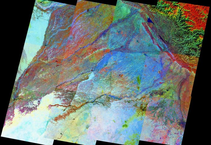
A remotely sensed image of NW India and part of Pakistan by Dr Philippa Mason, Department of Earth Science and Engineering, reveals a palaeochannel.
Dr Philippa J Mason’s remote sensing work has been integral to a paper published in Nature Communications today on Himalayan river morphodynamics.

Dr Mason is actively involved in the processing, enhancement and interpretation of remotely sensed imagery, and such work has helped to answer the question: ‘Was there ever a Himalayan-fed river to supply Bronze-age Indus Civilisations along the Ghaggar-Hakra palaeochannel in NW India?’
The remotely sensed imagery of this 325,000 km2 area – covering NW India and part of Pakistan – reveals a palaeochannel, a historic river which has shifted, over time and through natural processes, to form a new river channel through a process known as avulsion.
The research began ten years ago, with an undergraduate student project involving the selection, download and processing of many Landsat satellite images. Some 12 Landsat scenes were used to make this mosaic image. Dr Mason then processed the Landsat spectral bands – enhancing and balancing the images to allow comparison between 12 scenes. The spectral processing revealed that the surface materials in the palaeochannel are damp, reddish in colour (later shown to be silt rather than sand) and slightly cooler than the surrounding areas. In this image, we see river channels appear in blue tones as they are cool, damp and quite dark compared to the surrounding warm, dry alluvial fan sediments, except for one (the Ghaggar-Hakra palaeochannel) where, despite what the image may suggest, there is presently no river.
“Using this brightly coloured Landsat mosaic, the team was able to plan and programme extensive drilling, fieldwork and sampling programmes along and around the palaeochannel, the results of which have since proved that that there was no active river channel at the time of the Bronze-age Indus civilisations", Dr Mason says.
“We used Landsat for this work because it has a 40 year global archive, each scene footprint is large and it’s freely available. Some of the initial challenges included finding the right time of year to avoid cloud obscuring the ground and making the images unusable, so the images you see here were acquired post-monsoon, in November.” All the images acquired were from 1998, at a time which ensures most geomorphological features of the area are still visible, and not obscured or changed by recent human cultivation and urbanisation.

From analysing the geomorphology, they found that the palaeochannel is channel-like but the active river channel predated civilisations in this area. This was understood by sampling and dating of mineral grains through Optically Stimulated Luminescence (OSL).
The research involved international teams with whom researchers in the Earth Science and Engineering Department shared their knowledge of how to ‘read’ the satellite images. Undergraduate students on Undergraduate Research Opportunities Programme, UROP, were critical to the early analysis of the data.
The area imaged is of considerable importance as the largest area of groundwater depletion in the world. So while for Dr Mason it is especially satisfying to see a decade of work come together, it will surely spur further research into aquifer characteristics and into groundwater availability and quality in this region.
Read more about this research in Nature Communications, 'Counter-intuitive influence of Himalayan river morphodynamics on Indus Civilisation urban settlements'
Article text (excluding photos or graphics) © Imperial College London.
Photos and graphics subject to third party copyright used with permission or © Imperial College London.
Reporter
Victoria Murphy
Institute of Global Health Innovation