Tech foresight practice maps the future of urban air

Map - the future of urban air
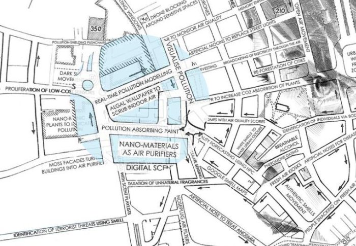
Specialists in air quality and tech foresight have unveiled an interactive map of technologies and designs that could affect the future of urban air.
The Imperial Tech Foresight team created the map in collaboration with futurist Richard Watson and academics from the Imperial Network of Excellence in Air Quality (NexAir).
Trends and innovations
Dr Audrey de Nazelle, senior lecturer in Imperial’s Centre for Environmental Policy and the leader of the network, said: “With this map we aim to help individuals and organisations understand what the future of urban air related technologies, policies and behaviours may look like.
“It is agnostic about what it should look like, but aims to show trends and innovations in that space, to help identify opportunities to improve air quality while also considering how some directions may lead to further co-benefits or trade-offs.
“Researchers from all of our faculties, brought together under the NexAir network, are working across all aspects of these issues to ultimately promote a healthy, smart, resilient and sustainable society.”

Beyond air pollution
The map represents a unique collaboration between academics, futurists, fine artists and the Imperial Tech Foresight team. Together, the creators examined the effects of urban air and explored the ways that these could change with the introduction of future technologies and social interventions.
“We breathe air, move through air, and touch air, yet it remains invisible to us. In this project, we explored ways that urban air shapes our lives in ways we don’t always notice”, said Maria Jeansson, Strategy Manager at Imperial Tech Foresight. The map explores issues beyond air pollution, highlighting other ways that urban air affects us, such as the sensory effects of smell, sound and light in current and future cities.
Richard Watson, futurist and visiting researcher in Imperial’s Centre for Languages, Culture and Communication, said: “As we were developing the map, we were surprised with how much innovation is happening in air quality. However, most of the focus is on pollution. The map aims to adopt a more holistic perspective that accounts for the sensorial consequences of urban air and future interventions.”
Themes
Findings from the future of urban air map include:
-
From invisible to visible
Air is an invisible medium and it’s easy to forget about the journey that our urban air has made. Many people in the UK were surprised when the sky turned orange as a result of desert sand blown from the Sahara in 2019. Technologies that make the impact air more visible could help improve urban air: for example, big data tools for tracking air quality in cities, low cost sensors for monitoring indoor environments, or augmented reality for viewing pollution in real time. -
Senses working overtime
Pollution is not limited to what we inhale: noise pollution also poses a serious threat to human health. New technologies could help prevent cities becoming unliveable due to noise. The map highlights examples such as unique forms of tarmac that lead to quieter road surfaces, metamaterials that could help silence buildings and cities with cladding made from novel materials.
The map also addresses the sense of smell and the risk of sensory overload through fragrances. In future, the map suggests, people might navigate the urban environment using smell maps. And we might decide to tax individuals with an overbearing fragrance footprint.
-
Socio-economic air divides
Pollution does not affect the rich and poor equally and there are links between socioeconomic status and exposure to air pollution. The map highlights issues such as the prevalence of ‘smog refugees’, who leave cities in search of clean air, and fresh air tourism, where hotels and stores aimed at the luxury market promote a clean air experience. Inequality is not limited to air pollution and there are risks of similar issues with noise and light pollution.
Making the map
Foresight is a process for discovering what is changing in the world and addressing this with forward-thinking actions. To make the map, the team used a traditional foresight process, gathering broad data points across different areas to identify ‘weak signals’ of change that could point to more dramatic changes in the future character of urban air.
They sought expert perspectives about the data points from Imperial academics in the NexAir network, which brings together researchers interested in air quality from across Imperial’s faculties.
The map was brought to life by the illustrators Ed Fairburn and Viola Timoncini. They used an old map to map out a child’s face out of the roads of the map. The point of the map show the impact of air pollution on the mouth, head, eyes, nose and skin.
Explore the map
View the interactive map.
For a PDF version, email the Imperial Tech Foresight team.
Article text (excluding photos or graphics) © Imperial College London.
Photos and graphics subject to third party copyright used with permission or © Imperial College London.
Reporter
David Silverman
Communications Division