‘Rock recorders’ reveal drastic drop in earthquake hazard forecasts for LA

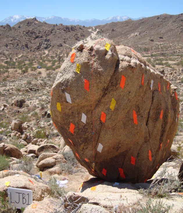
Precariously Balanced Rocks (PBRs) in Lovejoy Buttes.
Imperial College London scientists have challenged existing earthquake hazard estimates for the San Andreas fault near Los Angeles.
The fault marks where two tectonic plates meet, and is responsible for some of California's largest earthquakes.
The latest seismic hazard assessment, led by researchers at Imperial, suggests that the hazard of a giant earthquake on the Mojave section of the San Andreas fault area – the closest section to greater Los Angeles – is much lower.
The team found that in the unlikely event that a once-in-10,000-years earthquake erupted on the San Andreas fault, the ground would shake 65 per cent less violently than previously thought.
The ground shaking uncertainty range was 72 per cent lower than previous estimates – meaning that researchers are much more certain about the new estimate compared to previous estimates.
Earthquake 'rock recorders'
To reach this conclusion, researchers investigated a group of precariously balanced rocks (PBRs) at Lovejoy Buttes, an area found 15 kilometres away from the San Andreas fault.
PBRs are naturally balanced rock formations which are found worldwide and provide ancient geological data. Despite their delicate balance, PBRs have survived thousands of years of earthquakes without toppling, revealing insights into prehistorical seismic activity. In this way, they act as ‘inverse seismometers’ or earthquake ‘rock recorders’, as described by the researchers – since the PBRs have not toppled, they record ground shaking of large earthquakes that have not happened.
Senior author Dr Dylan Rood, from the Department of Earth Science and Engineering (ESE) at Imperial, said: “Earthquake hazard scientists are usually limited in their estimation of future earthquake hazard by the fact that modern seismometers have only been recording earthquake shaking for approximately the past hundred years. Therefore, when it comes to less frequent earthquakes happening over tens of thousands to millions of years, estimates become highly uncertain as more assumptions need to be made.
“Our groundbreaking ‘inverse seismometers’ technique allows us to forecast large, infrequent earthquake ground shaking more precisely. These precariously balanced rocks overturn the hazard model for the San Andreas fault nearest to Los Angeles.”
Findings could guide plans for emergency responses
By precisely dating the age of the PBRs at Lovejoy Buttes and examining their structural fragility (and therefore the likelihood of toppling due to ground tremors), the team at Imperial obtained key information about what intensity of ground shaking can be expected during these rare, powerful San Andreas fault earthquakes.
The findings were presented at the AGU Annual Meeting last month and are published today in Seismological Research Letters.
First author Dr Anna Rood, seismic hazard scientist at the Global Earthquake Model Foundation and ESE and Civil and Environmental Engineering alumna, said:
“We have innovated and implemented the most rigorous PBR validation methods to date. This is an important advance in earthquake hazard analysis, and practitioners should incorporate these methods. Our improved estimates have implications for the seismic hazard assessment of greater Los Angeles, which guide plans for disaster preparation, emergency responses and building codes. While a reduction in hazard may comfort residents of this earthquake-prone region, the magnitude of the inconsistency between our previous hazard estimates and the PBR survival raises important questions about our understanding of earthquake processes.”
Researchers emphasised the need for independent data to validate seismic hazard estimates going forward. To improve the accuracy of estimates, they stress the importance of utilising the unique data over the timescales of rare, large earthquakes provided by fragile geologic features such as PBRs.
Next, the team will use their inverse seismometer technique to validate seismic hazard estimates for other areas, including the Cascadia Subduction Zone in the Pacific Northwest, USA. Subduction zones generate the largest earthquakes on Earth, yet important questions remain about past and future shaking during magnitude nine megathrust earthquakes.
The study was funded by the Southern California Earthquake Center (SCEC), the Lawrence Livermore National Laboratory, the US National Science Foundation and the Engineering and Physical Sciences Research Council (EPSRC) in the UK, part of UKRI.
‘San Andreas fault earthquake hazard model validation using probabilistic analysis of precariously balanced rocks and Bayesian updating’ by Anna H. Rood, Peter J. Stafford, Dylan H. Rood published 17 January 2024 in Seismological Research Letters.
Article supporters
Article text (excluding photos or graphics) © Imperial College London.
Photos and graphics subject to third party copyright used with permission or © Imperial College London.
Reporter
Diana Cano Bordajandi
Department of Earth Science & Engineering