Structural Analysis with Radar Remote Sensing (StARRS)
Academic Team: Dr James Lawrence (PI – Imperial)
Research Team: Stewart Agar (PDRA – Imperial), Anthony Carpenter (PDRA – Imperial)
Funding: Nuclear Liabilities Fund (NLF) via EDF
Duration: April 2023 – April 2025
Overview
The Structural Analysis with Radar Remote Sensing (StARRS) project began in April 2023, with funding from EDF Energy. StARRS applies satellite and ground-based Interferometric Synthetic Aperture Radar (InSAR) technology toward monitoring nuclear decommissioning infrastructure and the surrounding natural environment. The StARRS research programme comprises of two sub-projects:
· StARRS-Cloud: Developing a highly automated InSAR detection system for nuclear infrastructure health monitoring.
· StARRS-Ground: Developing and coupling ground-based radar systems with satellite InSAR for nuclear infrastructure structural health monitoring.
The academic and research team comprises members of the Geotechnics Section, with extensive background experience in nuclear engineering, remote sensing, and InSAR.
Background
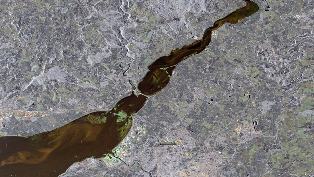
Interferometric Synthetic Aperture Radar (InSAR) is an active remote sensing technique, used for the precise quantification of earth and structural deformation. Current InSAR-capable satellites offer near real-time data updates (e.g., every 6 days for Sentinel 1), near-global coverage, and in many cases make their data freely available. Through InSAR analysis, millimetric movements of ground and infrastructure can be measured. At Imperial College London, we have developed in house ‘OpenInSAR’ analysis software, and downscaled radar technology with a drone-borne InSAR system.
StARRS-Cloud
The StARRS-Cloud sub-project will utilise existing OpenInSAR software, developed at Imperial College, to produce a highly automated system for monitoring structural health via analysis of satellite SAR data, specifically developed for EDF’s decommissioning of nuclear infrastructure programme.
The objective of this project is to expand OpenInSAR using machine learning (ML) techniques such as Recurrent Neural Networks and Bayesian Online Change Detection to automate the detection and analysis of potential hazards. Key insights regarding structural health will be distilled to monitoring teams in regular intervals, as satellite platforms continually capture data.
As part of this work, there will be significant efforts to futureproof OpenInSAR to maximise its value over the long (c. 80 year) timescales involved in UK nuclear decommissioning. Cloud computing interfaces, Application Programming Interfaces (APIs), and user interfaces for a range of programming languages will be developed. The software is open source and invites contributions and testing.
StARRS-Ground
The StARRS-Ground sub-project will use ML in the development of a ground-based InSAR system, to:
1. Automate the detection of potential hazards highlighted through InSAR.
2. Increase the speed, resolution and reliability of quantifying techniques for the SHM of nuclear infrastructure compared to satellite InSAR and conventional monitoring techniques.
3. Couple the ground-based and satellite InSAR results for validation, and to provide a complete monitoring overview at various spatial and temporal scales.
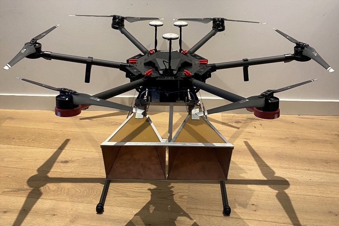
A ground-based (remotely operated vehicle (ROV), drone, portable) radar system will be developed, capable of providing long-term InSAR monitoring of infrastructure surface deformation and time- series data which can be coupled with the outputs of existing InSAR satellites by:
1. Allowing the user to focus on areas where satellite InSAR has low coherence or visibility, such as shadowed areas of buildings, with control over flight or scanning paths and geometries. A GBS may also be utilised for monitoring the internal features of infrastructure.
2. Controlling the return period of surveys (hourly, daily, weekly etc.) to provide improved temporal resolutions.
3. Providing vastly improved signal coherence and data resolutions due to the short-range applications and customisability of the radar hardware and software.
ML techniques will be utilised to automate the data coupling, provide repeat surveys through flightpath and scanning geometry analysis, and highlight areas required for repeat surveys, such as those with weak signal or identified as potential hazards due to surface deformation.
The developed systems are expected to be valuable tools for EDF Energy’s long-term monitoring of nuclear infrastructure. The systems analysis is expected to provide expedient information to save operators time and reduce the burden on manually intensive inspections.
Publications
Mason, P.J., Devanthéry, N., Camafort, M., Scoular, J., Payàs, B., Lawrence, J. and Ghail, R.C. 2022. InSAR and Earth Observation techniques for infrastructure (C805D). CIRIA, December 2022.
Carpenter, A., Lawrence, J.A., Ghail, R. and Mason, P.J., 2023. The Development of Copper Clad Laminate Horn Antennas for Drone Interferometric Synthetic Aperture Radar. Drones, 7(3), 215.
Wang, Z., Lawrence, J., Ghail, R., Mason, P., Carpenter, A., Agar, S. and Morgan, T., 2022. Characterizing Micro-Displacements on Active Faults in the Gobi Desert with Time-Series InSAR. Applied Sciences, 12(9), 4222.
Scoular, J., Ghail, R., Mason, P. and Lawrence, J., 2022. Are measured InSAR displacements a function of the chosen processing method? Quarterly Journal of Engineering Geology and Hydrogeology, 55(4), 2022-049.
O’Connor, W., Mider, G., Lawrence, J.A., Agar, S., Mason, P.J., Ghail, R. and Scoular, J., 2021. An Investigation into Ground Movement on the Ventnor Landslide Complex, UK Using Persistent Scatterer Interferometry. Remote Sensing, 13(18), 3711.
Mider, G., Lawrence, J., Mason, P. and Ghail, R., 2020. Monitoring Littoral Platform Downwearing Using Differential SAR Interferometry. Remote Sensing, 12(19), 3243.
Scoular, J., Ghail, R., Mason, P., Lawrence, J., Bellhouse, M., Holley, R. and Morgan, T., 2020. Retrospective InSAR analysis of East London during the construction of the Lee Tunnel. Remote Sensing, 12(5), 849.
Scoular, J.M., Croft, J., Ghail, R.C., Mason, P.J., Lawrence, J.A. and Stoianov, I., 2020. Limitations of Persistent Scatterer Interferometry to measure small seasonal ground movements in an urban environment. Quarterly Journal of Engineering Geology and Hydrogeology, 53(1), 39-48.
Agar, S.A., Lawrence, J.A., Ghail, R.C., Mason, P.J. and Thompson, S., 2018. PSInSAR remote sensing observations of deformation behaviour at Salisbury Plain, UK. In Engineering in Chalk: Proceedings of the Chalk 2018 Conference, 269-274. ICE Publishing.
Contact Geotechnics
Geotechnics
Civil and Environmental Engineering
Skempton Building
Imperial College London
South Kensington Campus
London, SW7 2AZ
Telephone:
+44 (0)20 7594 6077
Email: j.otoole@imperial.ac.uk
Alternatively, you can find a member of Geotechnics staff on the Department of Civil and Environmental Engineering website.
Follow us on Twitter: @GeotechnicsICL
We are located in the Skempton Building (building number 27 on the South Kensington Campus Map). How to find us