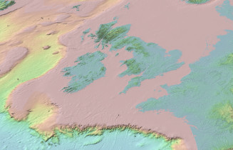
Throughout much of the Quaternary period large expanses of the UK continental shelf was exposed as dry land (Fig.1). As the ice sheets advanced, the major rivers of southern England and northern France extended out onto this ever growing land expanse. However, when the ice sheets melted, the areas were drowned, except a chalk ridge stood between southern England and northern France such that the English Channel and North Sea were separate water bodies. We have used a variety of marine geophysical methods to explore these ancient landscapes, many of which are preserved on the floor of the present English Channel.
Publications
García-Moreno D, Gupta S, Collier JS, et al., 2019, Middle–Late Pleistocene landscape evolution of the Dover Strait inferred from buried and submerged erosional landforms, Quaternary Science Reviews, Vol: 203, Pages: 209-232, ISSN: 0277-3791
Gupta S, Collier JS, Garcia-Moreno D, et al., 2017, Two-stage opening of the Dover Strait and the origin of island Britain, Nature Communications, Vol: 8, ISSN: 2041-1723
Collier JS, Oggioni F, Gupta S, et al., 2015, Streamlined islands and the English Channel megaflood hypothesis, Global and Planetary Change, Vol: 135, Pages: 190-206, ISSN: 0921-8181
Garcia-Moreno D, Verbeeck K, Camelbeeck T, et al., 2015, Fault activity in the epicentral area of the 1580 Dover Strait (Pas-de-Calais) earthquake (northwestern Europe), Geophysical Journal International, Vol: 201, Pages: 528-542, ISSN: 1365-246X
Gupta S, Collier JS, Palmer-Felgate A, et al., 2007, Catastrophic flooding origin of shelf valley systems in the English Channel, NATURE, Vol: 448, Pages: 342-U5, ISSN: 0028-0836
Return to Jenny Collier's homepage